How well do satellite and reanalysis precipitation products capture North American monsoon season in Arizona and New Mexico?
Precipitation is a critical component of the hydrological cycle ). As Earth's climate changes, the need for an accurate understanding of regional precipitation patterns and trends becomes ever more critical. Precipitation data can be obtained through various sources including gauges, satellite remote sensing, ground radar, reanalysis, or a combination of them.
Due to the localized nature of precipitation events, especially those that are extreme, individual rain gauges and gauge networks provide the most accurate precipitation measurements. However, they are geographically sparse, especially in remote areas, and suffer from sample measurement, and under-catch errors. Remote sensing precipitation products mitigate some of the shortcomings of the gauges by incorporating observations from thermal infrared sensors and passive microwave sounders). However, remote sensing products may have significant biases due to systematic and random errors in their retrieval algorithms, inadequate temporal sampling, relatively poor performance over snow and ice surfaces, and relatively short data records.
Reanalysis products benefit from data assimilation systems that incorporate available observations (in-situ and remotely sensed data) into numerical models. Although reanalysis products have an extended temporal estimation (e.g., over 40 years) of precipitation, their reliability depends on observational constraints, which can vary significantly over space and time. Ground-based precipitation radars provide near real-time coverage with a high spatiotemporal resolution. However, they have some limitations, including the attenuation of the signal interference of the curvature of the earth with the beam at long distances, and the high cost of the equipment.
The Southwest United States (U.S.) is a unique region as it frequently experiences multi-year and multi-decade episodes of severe drought, as well as frequent flooding events. This region also experiences changes in the magnitude, timing, and frequency of precipitation which have been linked with changes in soil health, ecosystem processes, and vegetation across the desert Southwest. Regional precipitation patterns in the Southwest U.S. are also of great importance since agricultural exports and ranching in the region are heavily dependent upon them.
An important climatological phenomenon in the Southwest U.S. is the North American Monsoon (NAM) System, which on a synoptic scale is a change in upper-level (300–250 hPa) circulation patterns that bring moisture flow into the Southwest region. Specifically, the upper-level patterns change from westerly to easterly over the region, causing the monsoon high and ridge to propagate northward, inducing cyclonic circulation, which facilities convection and promotes moisture flow into the area. There have been many discussions about the source of low-level moisture that contributes to NAM precipitation, but the literature generally agrees that the sources are the eastern tropical Pacific the Gulf of California, and the Gulf of Mexico. There is large interannual and annual variability of the NAM in the region due to shifts in the position of the monsoon ridge, which can help or hinder moisture flow. Precipitation during the monsoon season (i.e., defined as June 15th through September 30th) is typically responsible for roughly 50% of annual precipitation in parts of Arizona and the surrounding region.
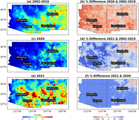
The NAM season of 2021 was one of the wettest in the region since 1895 and contained several extreme precipitation events. In contrast, 2020 was the second driest on record in many parts of the Southwest U.S. . Monsoon precipitation is already variable and the impact of climate change on precipitation extremes is largely uncertain. Furthermore, the uncertainty associated with precipitation products can limit their applications, especially in high-elevation areas and complex terrains that are known to have higher uncertainty. Shortcomings of these products are especially an issue in extreme precipitation situations that may lead to drought (over an extended period) or flooding and landslide events. Therefore, access to accurate precipitation data in the Southwest U.S. is critical for documenting the changes, evaluating regional climate modeling, performing impact assessments, and developing mitigation plans and adaptation strategies.
Knowing that various precipitation products exist over the Southwest U.S., an important question is how consistent these products are in capturing the extreme precipitation patterns, trends, and accumulations. In other words, the choice of precipitation product may impact applications, evaluation of models, or assessing future projections. The performance of the precipitation products and datasets have been evaluated over monsoon-dominated regions in other parts of the world. For example, the monsoon season in India has been heavily investigated using gauge products, and reanalysis products. The monsoon season in Eastern Asia has been similarly studied using reanalysis, and satellite-based datasets. The East and West African monsoon seasons have also been studied using satellite-based and reanalysis datasets. However, and to the best of our knowledge, only a few studies have evaluated satellite and reanalysis precipitation products for the NAM precipitation on a large scale over the Southwest U.S.
This paper focused on the Southwestern states of Arizona and New Mexico, as they are the two states most affected by the monsoon precipitation phenomena. Besides investigating precipitation patterns and times series for the entire period of study, this study focused on the last two years, 2020 and 2021, as they provide a unique opportunity to assess precipitation products under extreme dry and wet conditions and to investigate how consistent precipitation products are in capturing precipitation features (e.g., accumulation, spatiotemporal patterns, and extremes).

Datasets
Three satellite precipitation products [i.e., Integrated MultisatellitE Retrievals for Global Precipitation Measurement Late and Final runs, and Precipitation Estimation from Remotely Sensed Information using Artificial Neural Networks (, a reanalysis product [European Centre for Medium-Range Weather Forecasts (ECMWF) Reanalysis 5th Generation land component ( and one ground-based radar product
Story Source:
Materials provided by Weather and Climate Extremes. The original text of this story is licensed under a Creative Commons License. Note: Content may be edited for style and length.
Journal Reference: Science direct
0 Comments